
The first half mile to the Gunnison Route is misleading. The trail starts at Black Canyon of the Gunnison National Park’s South Rim visitor’s center as an easy nature hike, then it makes a steady descent closer to the rim, offering awesome views of the canyon. Through a tight grove of pinyon trees, hikers might notice another trail with a posted sign that reads: “Wilderness Permit Required.” This marks the beginning of one of the river access trails into the canyon. Anyone venturing on had better be ready for some of the most arduous non-technical climbing and scrambling in Colorado.
Early in the morning, my park ranger friend, Paul, and I parked at the visitor center and headed straight for the trail head for my first route to the canyon floor. Paul had done it last year. I confess I was a little nervous, especially after his warnings.
“We tell people it’s a very strenuous and difficult hike, not for your everyday hiker,” Paul had told me the day before as we planned for the descent. “People come back and tell us all the time it was far tougher than they’d expected. Some are even mad we didn’t caution them more.”
A few days earlier, the park almost launched an SAR (Search and Rescue) after a hiker reported a man struggling on the same route we were taking. He refused assistance, and several hours later made it safely, if not exhausted, back to the visitor’s center. A month after that, a 49-year-old woman died on the same trail. And the Gunnison Route is considered the “easiest” of the five routes to reach the Gunnison River.
Still, more and more people want to hike down. “People are waiting for permits before we even open the visitor’s center,” Paul said. “But we need to minimize impact by keeping it to a few groups.” Three routes start from the South Rim; two more are on the North Rim, but they are technically more difficult since they are covered mostly in scree, Paul warned. Paul’s status allowed us freedom to bypass the permits.
An hour before the visitor center’s opening, two men were already pacing outside as we passed them. We came to the Gunnison Route within a short ten-minute walk. Without knowing what to expect, I followed Paul on what would be the only set of switchbacks. After that, it would be all downhill, literally.
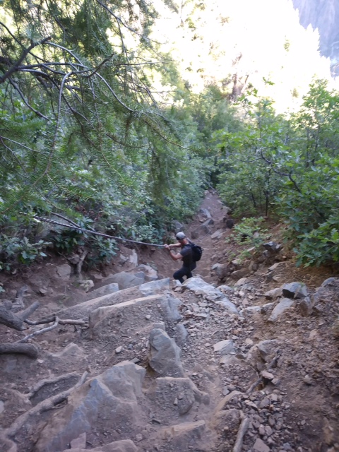
About a quarter mile in, the descent became so steep we had to scramble like crabs, using our hands and butts to keep us from toppling facedown into a freefall. I looked forward to the famous “chain” that eases the way down without tumbling. Ironically, I would learn the part with the chain was less steep than many other sections. Since I had the insight to wear canvas gloves, I used the chain to rapel. I impressed myself with the way I slid down, using my feet to jump off the mountainside. I couldn’t have imagined taking on the Gunnison Route without gloves. Hiking poles would have proved useless.
Past the chain, we slid on scree, and as we grew more fatigued, tripped over roots sticking up from the hardened ground. Nonetheless, the roots were invaluable for the descent, and later the climb up. “Thank you,” I said to the trees as I grabbed onto them like handles where the trail sloped 100 percent.
So many people had used the roots and nearby tree trunks for support, they were worn into a fine smooth surface from skin oils, making them resemble brown marble. Pinyon bushes and scrub pine would be ready to snag you should you fall. But off to the sides of the trail, stinging nettle also awaited. This innocent-looking white flowering plant has tiny needles that feel like hundreds of hot stings when touched, and it’s near impossible to avoid, as I found out. Trying to navigate down the steep descent while at the same time willing myself not to cling to the prickly plants did not come easy.
We passed a few hikers coming up from having camped at the river’s edge overnight. I did not envy them carrying backpacks while making the strenuous climb back to the rim, over 1,800 feet straight up.
“You think it’s easier coming up or down?” I asked one hiker, who had taken a breather to let us pass.
He tried to laugh between heavy breaths and shook his head. “Not in this case,” he said.
Except for a few stretches, the trail is mostly covered in shade. However, Paul and his fellow rangers advise people to hike early in the morning to avoid the rocky cliff side heating up from the sun, and to avoid hiking up in darkness.

We made it down in about 1.5 hours, which Paul said was quick. Seeing the frothy Gunnison River was never more gratifying. We relaxed by the river, eating lunch and napping, for about an hour. I wanted to put off facing the climb up.

No surprise, it was a lung buster. We scrambled on all fours at least one-third of the way. Again, I was grateful for my gloves. Warning: Don’t let the heavy large rocks fool you—they are not solidly in the ground and can easily be kicked out onto anyone hiking beneath you. The chain was harder to hold for the ascent. I dug my boots onto roots and any well-worn grooves. I believe the hiker we crossed was correct. Going up posed a special challenge.
Coming to the flatter switchbacks just before the “permit required” sign gave us a sense of relief. We knew we were in the home stretch. Even with several water and breath catching breaks, we made it up in under two hours, another “record,” according to Paul.
Despite the dangers, the trail offers amazing scenery and an atypical hiking experience for those in good health. There’s something special about seeing the river that shaped the canyon up close and personal. Taking on one of the “routes” at Colorado’s Black Canyon was both strenuous and rewarding.

Sounds intense, man. Wish I was in Colorado.
LikeLiked by 1 person